- Fri 14 December 2012
- Cartographica
- Rick Jones
- #Add Features, #buffer
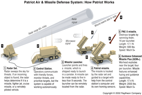
The violence associated with the Syrian revolution continues to escalate as recent reports have indicated that Bashar Al-Assad's forces have begun to use SCUD missiles in attempts to drive back rebel forces in the area near the Syrian Capital. SCUD missiles are infamous for their use by former Iraqi dictator Saddam Hussein during the Persian Gulf War. Equally as infamous are the U.S. produced Patriot Missile systems that are designed to eliminate surface-to-surface missile attacks. Recent reports have indicated that American, German, and Dutch patriot missile battalions have been sent to Turkey to eliminate the risk to the Turkish people from possible SCUD missile attacks from across the Syrian border. Check out the article on the Huffington Post about the recent visit from U.S. Defense Secretary Leon Panetta's visit to Turkey regarding the Syrian conflict and the U.S. Patriot Missile response. See below for a diagram from Raytheon for how the Patriot Missile system works.
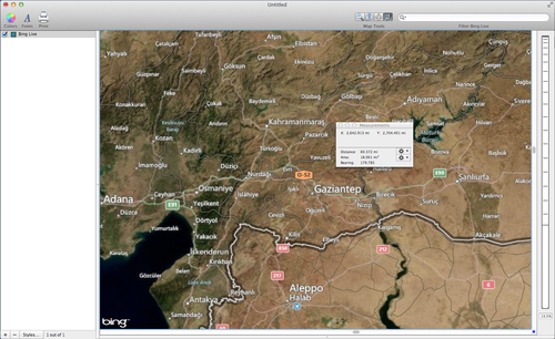
In order to add more context to situation we have created a few maps to highlight the areas where the Patriot Missile systems are being deployed. The Patriot Missile systems are being deployed to Kahramanmaras, Turkey, which is about 70 miles North of the Syrian border. We can confirm the distance between Kahramanmaras and Syria by using Cartographica's Live Maps and measurement tools. See the image below for an example. To add a Live Map, Choose Tools > Add Live Map, and to use the measurement tools click on the measure tool button and then drag a line to determine the distance.
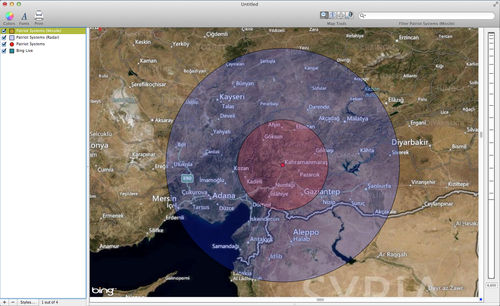
We can also look at the radar and missile ranges of the Patriot Missile systems by using buffers. The radar used by the Patriot Missile system has a detection range of about 180 miles in all directions around the system. The map below shows how far the systems deployed in Kahramanmaras will be able to detect incoming SCUD missiles. To create the map you first need to add a new layer by choosing Layer > Add Layer. Add a new feature to the layer by choosing Edit > Add Feature and then select to add a new Point feature. Create a buffer for the point by Choosing Tools > Create Buffer for Layer's Features. Make the buffer for 180 miles.
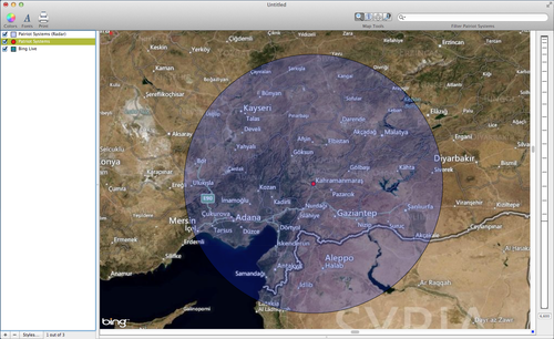
You can add to the map above by also creating a buffer for the effective range of the Patriot Missiles. The range is about 70 miles. Using the same steps as above create a second buffer for 70 miles. The map below shows the results.