- Tue 17 July 2012
- Featured Maps
- Rick Jones
- #health
The recent Supreme Court decision to uphold President Obama's health care plan has been received with mixed feelings across U.S. states. The goal of the health care plan is to ensure that all American's have an equal opportunity for health care insurance. A key aspect of the Obama health care plan was to expand Medicaid to cover those who were not covered by Medicare. This expansion was meant to fill the gap for people who couldn't afford insurance, but were determined to be poor enough to be exempt from the penalty for not holding insurance. The penalty for not obtaining insurance under the new plan was determined to be a tax by the Supreme Court, which contended that it was up to the states to decide whether they wanted to accept federal monies to fund the expansion of their health care systems.
As a result of this decision there are many questions about where states stand on the health care issue. A recent report released by the Advisory Board breaks down the current standing of each state based on the state's political make up and whether or not the state is leaning toward voting in favor of Obama's health care plan. To see the interactive map click on the Advisory Board link above.
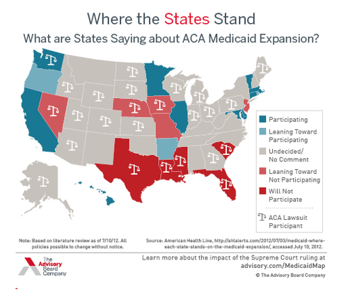
Based on the map you can see that five states (Texas, Louisiana, Mississippi, Florida, and South Carolina) have chosen not to participate in the Obama health care initiative. On the other side ten states (California, Hawaii, Washington, Minnesota, Illinois, Maryland, Delaware, Connecticut, Massachusetts, and Vermont) have decided to participate in the Obama health care plan. There are several states that are considering in favor or against the health care plan, and even more states that are undecided or have not released a comment about their stand on this issue.