- Mon 25 June 2012
- Cartographica
- Rick Jones
- #politics, #vector
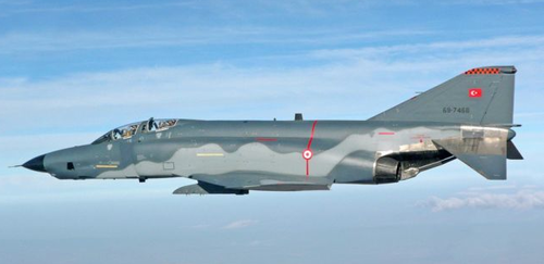
The recent troubles in Syria have escalated a little farther when Syrian Forces shot down an American made F-4 Phantom Jet flown by Turkey. Multiple news sources are reporting on this issue and there have been some inconsistencies about what actually happened. According to an article written in the Telegraph, the Turkish Foreign Minister has stated that the F-4 was shot down in international airspace after briefly entering Syrian airspace. The attack came without warning to the pilots of the jet. Secretary of State Hillary Clinton has condemned the attack and has been quoted as saying that the attack was "brazen". See the image below for an example of the F-4 jet.
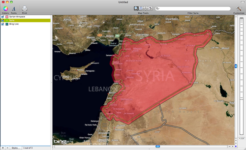
According to numerous sources the Syrian airspace extends 12 miles from its border and the Turkish jet may have entered the airspace. According to this report on the Syrian Arab New Agency, the plane was heading toward Syria and was shot down only 1km off of the Syrian border. However, numerous other news agencies are reporting that the plane was shot down in international airspace more than 12 miles from the Syrian border. To highlight the situation further I have created a few maps using Cartographica to provide more context to the reports that are currently swirling.
The first map below show the 12 mile airspace buffer around the Syrian border. To create this buffer I first created a new polygon layer based on the underlying Live Map. First, add the Live Map by choosing File > Add Live Map. Then click the + button at the bottom of the layer stack to add the new layer, then choose Edit > Add Feature. Choose Polygon, and then draw the polygon based on the boarder shown on the Live Map. Next, select the Syrian border layer in the layer stack, then to create the buffer, choose Tools > Create Buffer for Selected Feature. You will be prompted to set the buffer parameters. I selected Miles and typed in 12. The image below shows the results.
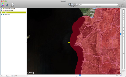
The second image below shows the site where I have deduced the plane was shot down. According to the Turkish Foreign Minister it was located about 13 miles off of the Syrian border in international airspace. I highlight the location using a yellow star. To add the yellow star click on the + button at the bottom of the layer stack. Then, choose Edit > Add Feature. Choose to add a point feature and place it on the map at the appropriate location. According to the report the plane was shot down west of the city of Latakia.
Keep an eye out on this situation as it unfolds. According to news reports Turkey is due to meet with NATO representatives on Tuesday to discuss the possible responses to be taken against Syria for its actions. Thus far the situation remains calm, but possible military action in the region is not impossible. The situation in Syria has continued to deteriorate over the past few months with the uprisings against Syrian President Bashar Al-Assad. This incident is only adding fuel to the fire.